| More menu items |

Drone Resources

Introduction Interest in aerial photography and/or videography using a drone is definitely growing, thanks to an ever-increasing availability to consumers of reasonably-priced drones. The quality of footage and photographs captured by these aerial platforms has kept pace as well. Since we are starting to see more aerial footage included in Multimedia SIG members' productions, we decided to add this page in order to provide some basic information to our members and other interested parties. We will try to keep any regulatory information up-to-date, but it is always the responsibility of the individual to keep themselves abreast of any developments in this field!! Here is the ultimate authority: Federal Aviation Administration Unmanned Aircraft Systems (UAS). |
Key Considerations
Know and understand the meaning of "Recreational Flight". Many people assume that a recreational flight is one that is not operated for a business or any form of compensation. But that's not always the case. Financial compensation, or the lack of it, is not what determines if the flight is recreational or commercial.
Non-recreational purposes include things like taking photos to help sell a property or service, roof inspections, or taking pictures of a high school football game for the school's website. Goodwill or other non-monetary value can also be considered indirect compensation. This would include things like volunteering to use your drone to survey coastlines on behalf of a non-profit organization. Recreational flight is simply flying for fun or personal enjoyment.
If what you are doing is not purely "recreational flight", then you must have Part 107 certification. This is not a simple, quick on-line test process. You'll need to study and then pay a fee and take the test at a certified FAA test facility (there's one near Tucson International Airport).
The following points are drawn directly from the Federal Aviation Administration web site and focus on recreational flying. If you don't know all the terms, you should make yourself familiar with them before you fly!
- Take The Recreational UAS Safety Test (TRUST) and carry proof of test passage to show to FAA or Law Enforcement officials upon request.
- Always avoid manned aircraft. If one approaches it is your responsibility to get out of it's way. It is not the responsibility of the manned aircraft!
- Never operate in a careless or reckless manner.
- Fly at or below 400' above ground level (AGL) in Class G (uncontrolled) airspace.
- Fly at or below 400' above ground level (AGL) in controlled airspace (Class B, C, D, E) only with prior authorization by using LAANC or DroneZone.
- Keep your drone within sight. If you use First Person View or similar technology, you must have a visual observer always keep your drone within unaided sight (for example, no binoculars).
- You cannot be a pilot or visual observer for more than one drone operation at a time.
- Do not fly a drone over people unless they are directly participating in the operation.
- Do not operate your drone from a moving vehicle or aircraft unless you are flying your drone over a sparsely populated area, and it does not involve the transportation of property for compensation or hire (that would fall under Part 107).
- If your drone weighs more than 0.55 pounts (250 grams), it must be registered with the FAA. (FAA Drone Registration). There are requirements about displaying your registration number on your drone, and you must carry your registration paperwork with you when operating your drone.
- You can fly during daylight (30 minutes before official sunrise to 30 minutes after official sunset, local time), or in twilight if your drone has anti-collision lighting.
- Minimum weather visibility is three miles from your control station. No, you can't fly in fog.
The foregoing information is a "brief" overview of what you need to know to start flying your drone. In the weeks to come, we'll continue to add material to this site, such as considerations for aerial photography and videography, recommended web sites for training and education, interesting equipment used by SIG members, and so on.
Pre-Flight Software
It will help if you know where you are allowed to fly so you don't inadvertently wander into restricted airspace and get yourself in trouble, "trouble" being defined as monetary fines and confiscation of your drone. There are some free tools (apps) that can help you with that problem! Note that different apps provide differing levels of information, and they are not always identical. Airmap will identify the Mount Wrightson Wilderness as a no-fly area while B4UFLY does not. However, don't think you can claim "But B4UFLY said it was OK!" as a defense when you get busted! It is your responsibility to properly do your research and determine if flight is permitted.
- Airmap. This free app is available at: https://app.airmap.com/
- B4UFLY. Another free app that also provides detail on restricted airspace.
- ArcGIS Web Application for FAA UAS Data on a Map. A more advanced application that is worth learning how to use. If you're flying anywhere near an airport or special use airspace you need to know this one! Visualize it: See FAA UAS Data on a Map (arcgis.com)
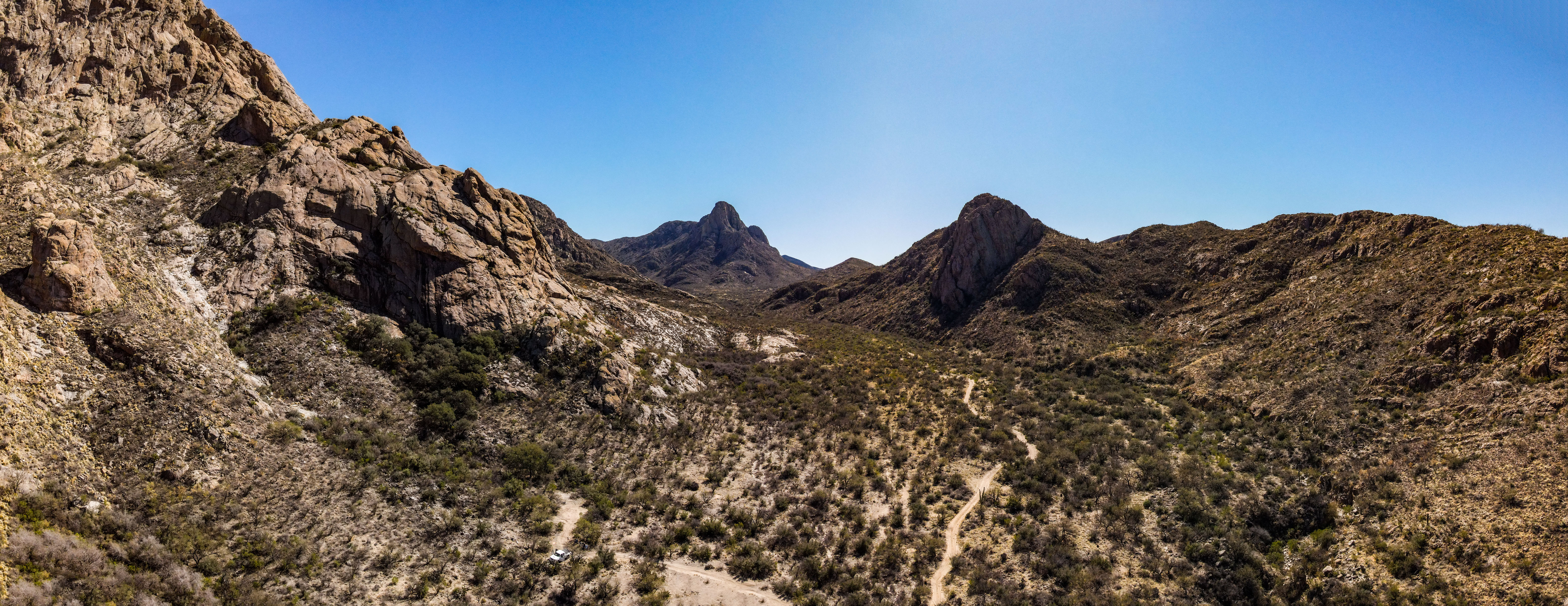
Chino Canyon - Photographer near white truck in lower center of photo.
Drone Websites
We're going start cautiously adding websites to this section that provide flame- and troll-free sources of information and advice from users in the drone community. If you come across a site you think is appropriate for this section, let us know!
- DJI Mavic Pilots Forum. Covers all the models DJI produces, drone news, regulation discussions, photo and video critiques and advice, and much more. We like this site because the moderators have a low tolerance for inappropriate postings and will delete that stuff quickly.
Don't Burn Your House Down! Or, What you need to know about batteries
Overly dramatic title? Maybe. But now that we've got your attention here's some good information concerning batteries for your drone that we picked off the MavicPilots.com forum. This was written by Forum User "Slup" from Sweden, who gave permission to reprint here.
Information about LiPO & LiIon batteries
-
Keeping the battery at 100% isn't good for it ... do what you can to minimize the time that they are at that level, the default auto discharge (if your batteries have that feature) down to 60-65% is way too long ... & if you check the level by pushing the button you reset the counter & the counter will restart. If a battery that is above storage % level haven't been used in a couple days, use the USB adapter from the Fly More Kit (if your model has that) to charge something else (your phone) in order to bring it down to storage % (see below ...)
-
Heat kills them ... don't store above room temperature & absolutely not in a car during summer, a couple hours in a burning hot car & the battery will sustain serious damage.
-
Let them cool down to room temperature before recharging them.
-
Don't fly with a battery colder than 15C degrees (59f), keep them warm in colder weather, have them in a pocket close to your body.
-
Store the batteries between 30-60% ... a good thumb rule is to take them of the charger as soon as the third led start to blink, then they are just over 50%. But anything between 1 solid + 1 blinking up to 2 solid + 1 blinking is good enough.
-
Don't drain them to low, make sure they don't go under 15% ... once in a while, so be it. Aim to not have them lower than 20% ... if you aim for that you usually don't end up below 15%.
-
Don't fly with a battery not recently fully charged, having a battery laying around partially charged for a longer period may make the cells in the battery unbalanced, using a unbalanced battery can make that lower cell fail soon after take off, & initiate a forced low battery auto landing you can’t stop.
-
If stored for a long time, cycle them at least once each third month ... then back to storage %.
Remember ... batteries will not last forever
...they will either slowly degrade to the point where the useful flight times are so short that you stop using it
...or it will have a sudden cell failure which will trigger a sudden forced auto landing in the worst possible place
...or it will slowly start to swell to the point where they not fit into the drone anymore
...or the swelling goes off instantly or gets worse when the battery gets hot & pushes itself out of the drone at height (i.e., in flight).
The only visual sign is swelling ... which does not always occur. Furthermore, different drone models have different possibilities to handle a smaller momentary swelling when hot during flight.
So a battery can't be judged only by that it takes a charge to 100%, isn't swollen & manage to power your drone without mishaps ... too much is going on hidden from just a visual inspection or a test flight, you may have been on the verge to a disaster without knowing it.
You have mainly 2 methods to both prolong the useful service life of the battery & prevent sudden failures ... & judge when it's time to either limit the flight duty (in colder temps for instance) or completely take it off flight tasks.
Battery Care.
Never keep the battery cell voltage outside 3,7-3,8v for a longer period than 48h (that is a battery charged to approx 50%). If too high after a flight, discharge them, too low charge them up to storage level again.
- Store them at room temperature ... (too warm is more damaging than too cold)
- Never let them overheat ... (left in the sun or thrown in a hot car)
- Don't charge them hot, let them cool down to room temperature
- Don't use cold batteries, try to have them at room temperature before using them
- Respect the operational ambient temperature specified in the user manual
- Don't push the battery for amp draw (both sticks on max inputs at the same time in Sport mode) when cold or hot ambient temps
- Don't fly them below 15% other in exceptional cases
- Always start a day of flying with the batteries freshly fully charged
Follow how the useful calculated max flight times change
- Compare the full charged max mAh compared to the designed mAh
- Monitor how the cell deviations degrades
For all points regarding the battery performance it's a question of trends over time ... just looking at a single flight will not give any insight over the actual health ... having a bit shorter flight time or some bigger cell deviations in one flight can be normal if using Sport mode or flying in colder ambient temps for instance. The paid Airdata subscriptions give the possibility to check these trends over all flight logs uploaded there ... it gives a good decision base to understand the battery health & if it's time to take it off duty.
Editor's Note: This information was posted by "Slup" in response to a posting by a flyer who was flying his Mavic 2 Pro on a three year old battery and it basically failed at 20 seconds into the flight! It went from 89% at takeoff to ZERO in 20 seconds, which meant it came straight down right now! I would love to be able to say, "Oh yeah, I do all that stuff!" but the truth of the matter is that I don't. Some I do, some I don't, and some I just flat didn't know about. But rest assured, I'm going to take a closer look at all of this! The dramatic heading is a nod to the dangers of Lithium batteries. I recently obtained a Pyrex dish at Goodwill that I now use to hold my lithium battery charging setup.
YouTube Resources
There are a few YouTubers that do a fine job with reviews and tutorials on drones and their use in photography and/or video.
- Tony and Chelsea Northrup. These long-time professionals in the field have been a great learning resource and not just in drone photography.
- Stewart and Alina. Please don't let the Scottish accent throw you! This couple bring a lot of very useful information to beginning drone photographers and videographers.
- UAV Coach. A source for regular drone news "roundups" and industry information, plus drone training.
- DJI. The official DJI site on YouTube.
- 51 Drones. A good source of reviews, testing and news on all things drone from a consumer viewpoint.
-
How to Fix Drone Anxiety - YouTube Lots of information presented in an entertaining way. New flyers should watch this!
 The GVR Photography Club is located in the Recreation Village of Santa Rita Springs.
921 West Via Rio Fuerte, Green Valley, AZ 85622
Phone 520-648-1315
If you have any questions or concerns please call the above number during business hours or email us at: gvrphotographyclub@gmail.com